
A new garden estate
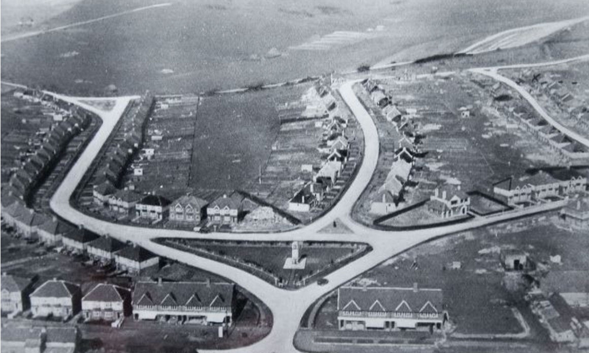
The development of the estate was initiated in 1931, when in November of that year, George Ferguson, purchased 75 acres of mainly pasture land, from Mrs Arethusa Stay of Place Farm to build an estate with all modern amenities. Inquiries came in from far and wide to examine the types of houses on offer. The all electric garden estate fitted in with the current culture of huge improvements in living standards. There were indoor toilets, fitted electric fires, running water and generous gardens. The brochures waxed lyrical about the advantages of living in Patcham; even showing how very near the sea it was.
Plan for 1,300 houses
George Ferguson had recently completed the Crabtree Estate in Lancing, and this new project turned out to be a mirror image of his last work. The original plan was to build 1,300 houses along the valley called Eastwick Bottom. Over three hundred workmen were employed to build a wide variety of properties, and convert the old Drove Barn into a church seating four to five hundred people. The estate was also going to have a swimming pool, landscaped gardens with bridge and waterfall, and a church and school situated in Plainfields Avenue.
Not welcomed by old village
The end of the estate at the top of the valley was going to have a green and there were 6 separate green spaces allocated to enhance the lives of the residents. Some of those projects didn’t materialise, but the resulting development was still regarded as amazing. The new bungalows and houses were very popular, and bought by all sorts of people – young couples, families, and even well heeled ladies and gentlemen for a retirement home. However, some of the long term residents of the old village disapproved of the open fields being trashed in such a manner, and refused to go and see the new housing. The comment was that they would rather see oxen than people on that land.


Comments about this page
Hi Georgie. I researched LME when I was doing my PhD on interwar Patcham and would love to meet up and chat about it – can you contact me please on g.mead@sussex.ac.uk
An interesting article, Georgie, though I am struggling to spot the mirror image of this on a map of Lancing. Can you help me with the names of the roads involved please? Regards
Alan, George Ferguson was a Scot from Kirkcudbrightshire who moved to SE England sometime around WWI and in 1918 developed a small estate at Tulse Hill, Brixton; he then obtained land at Lancing and around 1929 built the area south of the A27 just beyond the Lancing Manor roundabout. His LME development was in two tranches from 1931-1934 and 1934-36 and was the largest building project outside London at that time. (For more details…read my thesis…only 88,000 words!)
Apologies to Georgie and Alan! I mis-read your name Georgie (but DO get in touch please!) Alan. The reference to a ‘mirror image’ is to the architectural styles I believe, as the two estates, particularly the early LME section, are similar. Ferguson did one more big project, which was the Hassocks Garden Suburb which he commenced after LME in 1936. I have no information about anything post WWII so assume that was his last big scheme. Most of his estates have a ‘Mackie’ somewhere in their street names as his wife was a ‘Miss Mackie’ when they met. They all have road names reflecting his SW Scotland origins.
Thank you for the information, Geoffrey, but it doesn’t answer my query. Regards
Hi Alan, I think the term ‘mirror-image’ is the problem here. I believe Georgie is referring to the architectural styles of the Crabtree estate as being ‘mirrored’ with LME rather than the actual street layout.
Hello Geoffrey, because of the order in which our comments on 27/10/2015 have been published, it looks as though I still think you have not answered my query, when in fact you have! Thanks
Alan, having driven past the area for years on the A27, I was surprised how hard it is to locate on the map. I was also surprised to note that it is in fact about half the size of the Ladies Mile Estate. It is north of the A27, and the road names are: Herbert Road, Alandale Road, Hillside, Mountview, Sedbury, Howard and Valley Roads.
Hello Georgie. Thank you for your reply. So the estate you were referring to is actually north of the A27. That explains why I was unable to locate it from Geoffrey’s description! I can now see the mirror image. In Lancing, Steepdown, Valley and Sedbury roads meet at a triangular green, with the main development running off to the west. In Patcham, Mackie, Vale and Warmdene avenues meet at a triangular green, with the main development running off to the east. Many thanks.
Alan, Mea culpa! and how embarrassing to be not knowing north from south, and me a geography lecturer!
Not to worry, Geoffrey. I’m sure you know your north from your south really, but occasionally correctness goes west! Regards, Alan.
Add a comment about this page