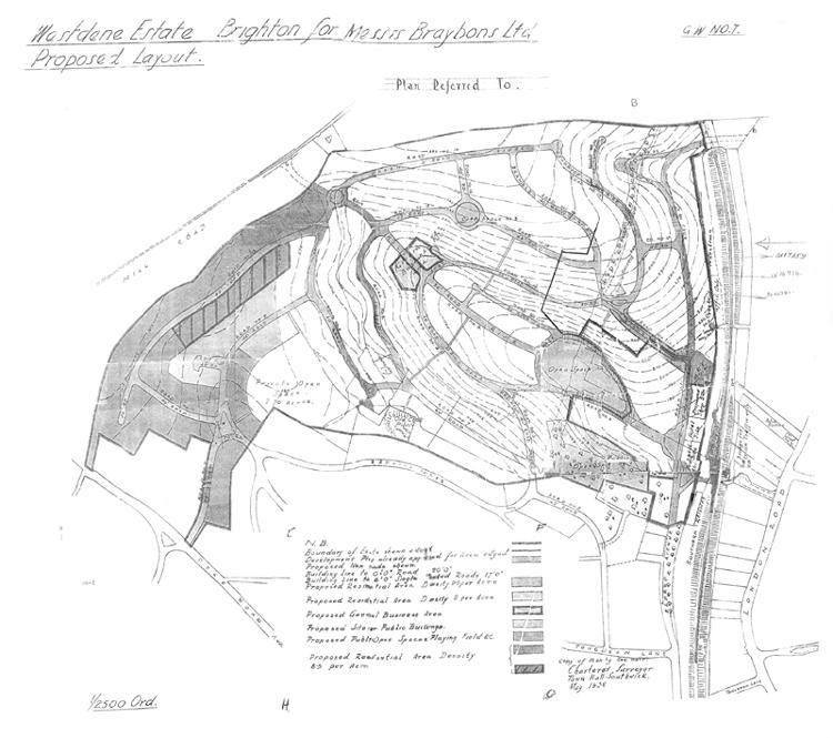
Open spaces
There are three public open spaces on the plan. Open Space No 1 is the eight-acre Westdene Wood to the west of Eldred Avenue. Nearby, Open Space No 2 is the playing field known now as ‘the green’. The third is a circular space below Green Ridge, which does not exist today but would have been in the vicinity of Highbank. These three pieces of land were to be sold to Brighton Corporation by 25 December 1938, the conveyancing costs–‘not exceeding ten guineas’–to be paid by the Corporation. [According to a settlement dated 5 September 1892, these spaces had previously been owned by Eldred Vincent Morris Curwen, Chaloner Frederick Hastings Curwen, Edith Margaret Spence Collis, Gilbert Robert Henry Collis, Henry Fraser Curwen, William Henry Domville and Charles Whitbread Graham.]
Each of these spaces was to be maintained by the Corporation as ‘a public open space, park, garden or recreation ground’, with the right to erect ‘pavilions, glass houses, toolsheds, shelters, conveniences or other buildings or erections for the better enjoyment of the said land’. However, there was an injunction against building public lavatories on Open Space No 2 (‘the green’) for five years. None was ever built. The space was later used for bowling greens; these were not popular, although the pavilion still stands beneath the trees. The children’s playground is enclosed by the wall of an old farmyard that was once attached to Newman’s Barn, which survived from the late 1700s until the early 1960s.
There is also a ‘private open space’ near the western end of the estate. This is the area between Redhill Drive and Millcroft that has caused recent controversy because of plans to develop housing on the site (see below).
Street names
Several street names are already present on the plan, albeit not always following the same line as at present. Working southwards from the top of the plan we find Green Ridge, which leads into Fernwood Rise at its eastern end, with Bramble Rise running parallel, much further east than its present line. These two meet at the top end of Copse Hill (Road No 21). There is no Windmill Drive as such (part of it is called Green Ridge), although there is a condition in the agreement that a road will be built between the top of Eldred Avenue and London Road above the southern end of the railway tunnel–a road that is now Brangwyn Crescent.
Mill Rise runs from the north-west of the estate in a straight line down to ‘the green’. At one point, where it is crossed by a long curving road, is a ‘general business area’. The southern part of this curve is called Dene Vale, but this now roughly part of Mill Rise, further west than today’s Dene Vale (Road No 2 on the plan). The road now called Fairview Rise was regarded as an extension of Redhill Drive. Road No 5 ran from Redhill Drive to the northern end of the then Colebrook Road near the junction of Hillbrow Road, and became the higher part of Colebrook Road.
Otherwise the roads are numbered rather than named. Road No 9 is the top of Valley Drive and Glen Rise, Road No 8 is Millcroft, Road No 7 is Hillcrest, Road No 6 is Westdene Drive, Road No 18 is Highbank and Road No 17 is Deneside. There was no provision for today’s Downside. The Ordnance Survey map amended to 1938 shows that Dene Vale and Barn Rise had already been developed with housing as far as Newman’s Barn.
All the roads and street works were to be built by Braybons within three years. Within six months of completion the Corporation was to reimburse half the cost.
Business and community
The ‘general business area’ on Mill Rise became Loyal Parade, a smaller and less focal shopping area than appears to have been intended.
The bridge under the railway on The Deneway is marked ‘for pedestrian traffic only’. Running north from the triangle of open land where The Deneway meets Eldred Avenue were proposed shops and, remarkably, a’ hotel site’. Again, this planned business area is larger than that actually built, stretching from The Deneway to a point opposite the lower end of Copse Hill.
The plan could be critised for not including schools, churches, pubs or any other community facilities, the nearest of which would have been some distance away. (Still the case with pubs!) However, a small church, the Church of the Ascension, was built on a difficult site at the corner of Dene Vale and Fairview Rise. It was dedicated in February 1958. Westdene (Primary) School was opened in 1961 in the centre of the estate–where Mill Rise had been intended to run–and the adjoining Westdene Library was opened on 13 March 1964.
The Braybon family clearly liked the area. Having had a home in Eldred Avenue, one of the first new houses was built on Redhill Drive at the corner of Colebrook Road and called Coppercliff. In 1965 it became a hospice for cancer patients. When the Martlets hospice in Hove opened in 1997, Coppercliff was renamed Outlook House and became a residential care home.
Private open space
For the record, paragraph 13 of the Agreement reads as follows:
‘The Owners shall not at any time use or permit to be used the land coloured green on the said plan and marked “Private Open Space” (hereinafter called “the Private Open Space”) and having an area of seven point seven (7.70) acres or thereabouts otherwise than as a ground for sports play rest or recreation or as an ornamental garden or pleasure ground and shall not erect a building or execute works required for or incidental to the purpose for which the said Private Open Space is reserved Provided always that if and when the said Private Open Space shall come into the ownership of the Corporation these conditions shall not apply but the said Private Open Space may thereafter be used for such purposes as the Corporation may determine subject nevertheless to the observance of the restrictions contained in the before mentioned Agreement dated the second day of July one thousand nine hundred and thirty four.’
The conditions of the agreement of 2 July 1934 are not defined but are the ones that applied to the public open spaces.
 This plan for the Westdene Estate was drawn up in May 1938 and attached to the agreement between Brighton Corporation and Braybon Limited, the developers.")


Comments about this page
I have been told (by an estate agent) that there is a covenant preventing the opening of pubs in the area to protect the morals of the residents. The Sportsman at Withdean Stadium is on Council property. He also said there was a covenant in the original deeds for each property prohibiting alterations to the building. Clearly this is no longer applicable – or at least no longer observed!
Unfortunately my mum died in Coppercliff in 1985, but 1 thing I remember about it is what a beautiful building. I remember looking out of Mum’s room window and seeing trees and green space. Such tranquility and beauty to surround such ill people. I have never been back since, unsuprisingly, but was amazed to see the information about Coppercliff on this site. I had no idea what had happened to it since the Martletts opened. A sad reason for remembering a beautiful building in a beautiful area of Brighton. I hope that the building that was Coppercliff remains for a long time to come as I’m sure it holds many memories for so many local folk!
Since my last comment, I have recently revisited the building which was Coppercliffe. As I was sitting outside, I was aware how peaceful and beautiful the house and surrounding area remains. In this epoch of rapid progress and change it was wonderful to find an area of Brighton that remains unchanged. Long may it continue in West Dene and for Outlook House!
I doubt many recall the 10-12 year old, yes (10-12), who used to cycle from the newsagents at Robertson Road, Preston, (after pushing the carrier bike up Black Hill), all up Dyke Road Avenue and Withdean delivering newspapers before and after school in 1953-1955. Supplementing this service on a Sunday, with collecting the money and delivering multi-packs of cigarettes, rain or snow. Mr Cohen (chairman of Alliance Building Society) was one customer. 55, D R A , he lived and I understood he sponsored Coppercliffes. Green Ridge used to run West from the bend at the top of Valley Drive and Glen Rise, went north from the same point, both were no-through roads, with the last building on the right at the top of Glen Rise, being called Gable End. Mrs Furner (music) and Mr Peckham (Head) of Stanford Road School lived on the left and right respectively. The round took in all the roads around including Tongdean Road, Gableson Avenue, Redhill Drive, Colebrooke Road, etc, then all the roads accessed from Snakey Lane on the way back. Withdean Court Avenue, Cedars Gardens, Elms Lea Avenue, etc. Please forgive any minor inaccuracies, it was after all over 50 years ago and I have not even been in that area since I was a Southdown bus driver in the mid Sixties. If you would like to have a Fifties childhood experience, do ‘get on your bike’, and try that route on a winter’s morning and a dark winter’s night. By the time I swapped rounds, I was at senior school and found out too late that the most beautiful girl in the world lived on that round in Eldred Avenue. But then, what chance against the head boy? NONE!
My late mum used to work at Coppercliff for 21 years before she had to retire due to ill health herself suffering from cancer. Coppercliff was such a beautiful place for many to end their days in dignity and comfort, the gardens were lovely for those well enough to enjoy a breath of fresh air…..
Its a beautiful area. I think it was a a shame the football stadium was opened up there in such a pretty place. In case anyone ever reads this and wonders who my mum was, she was Sheila Gohmann, a friend to many in their time of need.
Hello Liesa. My late Mum, Mary Doogan, worked with your Mum, Sheila Gohmann. Your Mum was one of my Dad’s favourite nurses at CopperCliff, along with Theresa Lelliott. He died there in 1969. You may remember me and my brother John Doogan? I have started a separate page on this website under Redhill Drive, specifically mentioning CopperCliff. I remember that your Mum was a great friend to so many, including my Mum.
Hi Maggie, thank you. I’m missing my mum badly right now, with her anniversary and Mother’s Day so close. Was your mum Sister Doogan on the maternity ward at the RSCH?
Hello Leisa. Yes, my dear Mum was Sister Doogan (Level 11, Maternity Ward) at the RSCH! She retired from there in 1983, but she carried on part time and died in 1987. She nursed at Coppercliff with your Mum. Other staff members from there I remember are Sister Margaret Lewington and Nurse Cissy Wallis. I still send Christmas cards to Matron Olive Burrage.
Friends of Westdene Green is trying to find out the story of The Barn on the Green from the days of ‘Newman’s Barn’ through bowling clubs to the present day. We are about to take a lease on The Barn with the local community and would like to be able to display some historical information. We have found some very old photos but not much written info. Hope someone can help!
Add a comment about this page