An interest in the past


The railway cutting between Addison Road and Highdown Road has fascinated me since moving to the Goldsmid area in 1994. My young son Tom loved to be held high on the Montefiore Road bridge, to watch the trains go by below. My interest is also in trying to comprehend the enormous amount of spoils removed during its construction. Sure, this is no particular special feat of civil engineering, however the sheer depth of the cutting made me think of the effort and manpower required to dig it.
South Coast Railway line and the cutting
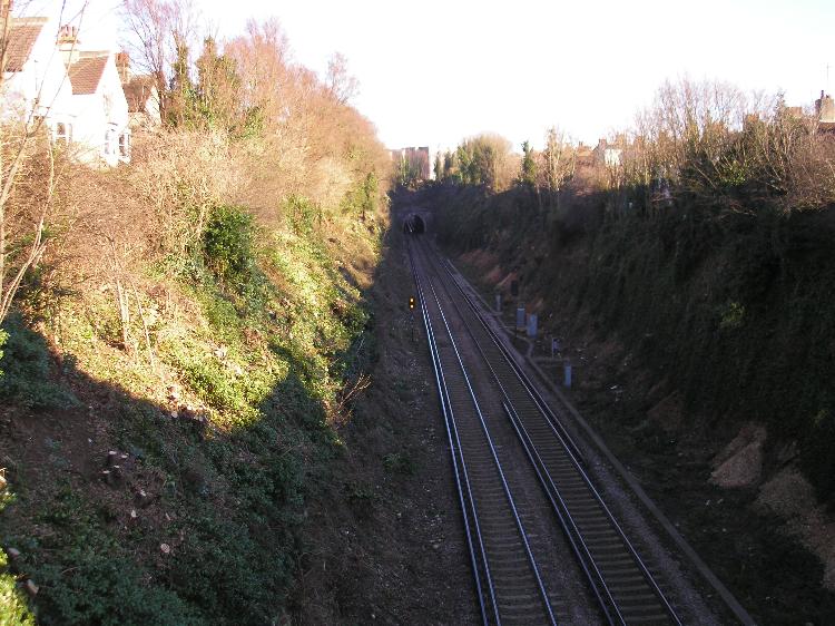
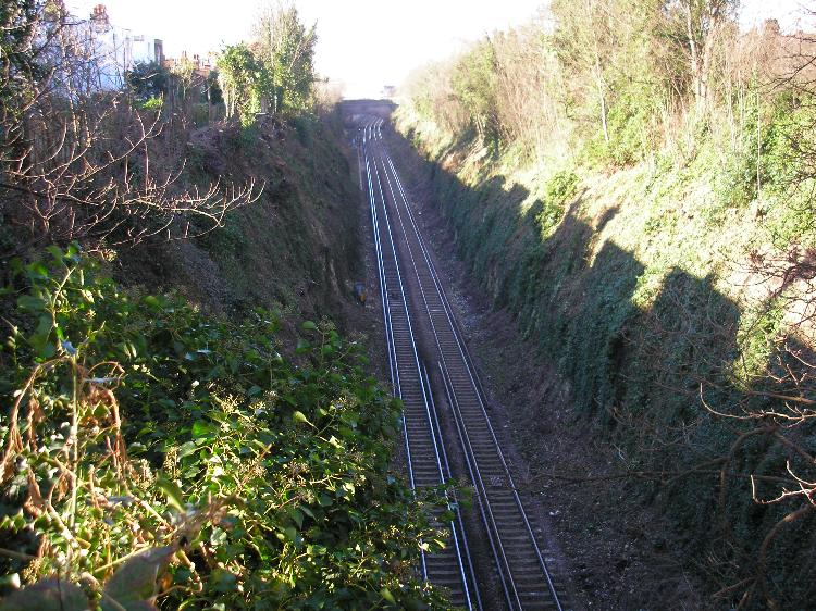
The South Coast Railway line to Shoreham opened in May 1840, just over a year earlier than the completion of the London to Brighton line in September 1841. The line leaves Brighton Station and sweeps round below Howard Terrace and under New England Road, then into the tunnel under Dyke Road, before emerging between Addison and Highdown Road in the deep cutting. At this point in 1840 the line ran through open land, the new development of Brunswick Town to the south beyond the Wick Estate. The depth of the cutting between the Dyke Road tunnel and Montefiore Road bridge is probably nearly 100 feet, and of significant width. The cutting shallows as it approaches the former position of the old original Hove Station and Holland Road Halt at the junction of Holland and Lyndhurst Road.
A number of the roads running southwards from the Holland Road bridge were built up using the spoils from the cutting. This is most noticeable on Holland Road and Palmeira Avenue, where the road is unnaturally higher than the ground on either side. Clearly this is most visible at the top end of Palmeira Avenue.
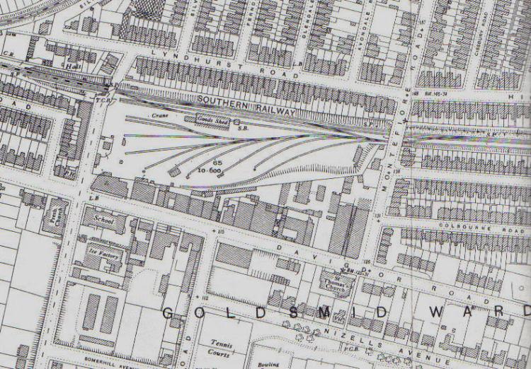
Original Hove Station
The original Hove Station was on the east (Wicks) side of Holland Road bridge. It opened with the line in 1840 to serve the new Brunswick development just down the road. It closed in 1880, having been superseded by Cliftonville and West Brighton Station, half a mile to the west in 1865, which was renamed Hove in 1895. Coal sidings were then built on the site of the old station and adjoining land to server the Electric Light Company.
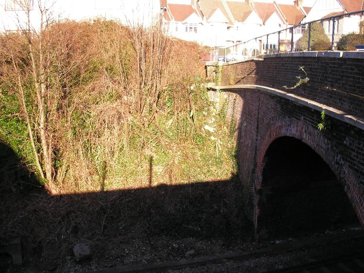
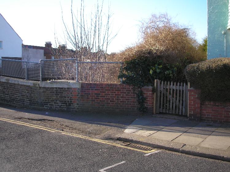
Poorly matching brickwork hides the past
Holland Road Halt opened in 1905 on the west side of the Holland Road bridge, opposite the site of the original Hove Station. Wooden platforms were on both the up and down side, accessible by flights of wooden steps, as the cutting was still quite deep. A small ticket office was on the north side. The station closed in 1956. A closer look at the wall around the bridge tells the story of where both entrances once were. Poorly matching brickwork hides the past!
Poorly matching brickwork has another story to tell close by in Lyndhurst Road, directly behind the station. In the early 1930’s a light aircraft crashed into the front garden of the house on the corner of Holland and Lyndhurst Roads. It clipped the roof before hitting the garden wall, which was mostly destroyed. Again a close inspection of the brickwork tells the tale of the past. Luckily the pilot bailed out and landed safely in Dyke Road.


Comments about this page
I was born in Addison Road in 1940 and looked out on this cutting all of my young life. Our house (No.41) had a wooden balcony at the back at the first floor level, making a useful vantage point. It is a fact that the cutting was so deep that you could not see the trains at all. There was also a considerable amount of shrubbery allowed to grow. Occasionally this was cleared away and a spot of trespassing allowed easy sight of the very frequent rail traffic below, both electric and steam. It was not unusual for a spark from a steam locomotive to ignite the bank on the opposite (Highdown Road) side. The fire brigade had to attend, attached to ropes secured at the top.
I grew up in Lyndhurst Road from 1952-1970 and remember the old halt on the west side of the bridge, as we used it for train journeys. The bridge was always exciting when steam trains passed under it and enveloped us all in smutty smoke! The banks always caught alight due to sparks from these trains in summer. Along the back of the houses on the south side of Lyndhurst Road and the fire brigade found lots of ‘willing helpers’ running in and out of the side passages between houses. I always wondered about the Highdown Road tunnel, but now use this stretch of line regularly and can see how deep it is.
I actually live in Lyndhurst Corner and believe that it was my garden that the aircraft crashed in (you can see our front door in the lowest picture). I would love to know more about this if anyone knows anything.
Hi Darren. Yes it was your garden the plane crashed in, well actually it was your garden wall. If you examine the brickwork you will see how the newer bricks don’t quite match with the old! Theres a photo of the crashed plane in one of the small paperback books on Brighton, plus a short account of the crash. I used to have the book but I think someone has “borrowed” it and not returned it, I cant remember who!
A photograph of the crashed plane is reproduced as photograph no.106 in James S.Gray’s book ‘Brighton between the wars’. The crash happened in January 1938 and I guess it will have been written up in one of the local newspapers of the time.
I also grew up in Lyndhurst Road in the 30s and early 40s. I can remember the light aircraft landing on a nearby property. One of the mothers who had come to collect a pupil from my school in Wilbury Villas recklessly announced that a plane had crashed on the corner of Lyndhurst Road. Suspecting it was my house, which was also on a corner of the road, I ran all the way home in a state of panic, only to find it was in the front garden of a house a little further up the road and no one was hurt!
I live in Holland Road, and not long after arriving here 30 years ago I learned a few things of interest from an elderly lady who had once lived in a bungalow where Amber Court is.
She was quite happy to tell me everything she knew about the immediate local history.
As has been mentioned above, the spill from the cutting was used to create the ‘elevated’ Holland Road. The purpose, apart from getting rid of all that chalk, was to make life easier for the horses that carried the coal from the depot (where Wickes is now) down to the Brunswick and Adelaide parishes. There was an incline descending from the depot down Holland Road before rising again at or near the Lansdowne Road junction. The horses would have had difficulty pulling the fully laden wagons up that slight hill so that was a real benefit.
She lamented the closing of Holland Road Halt as it had been a delight to hear the children squealing with joy during the summer months as they ran down from the station towards the distant sea. Most had never seen it, she believed.
In Victoria station London there is an old ceramic map of the southern region and Holland Road is marked there.
One other thing was when I was digging in my garden and turned up what looked like large hollow bullets. I took them to be some sort of embellishment for wooden palings, perhaps, and lined them up on the boundary wall.
Shortly afterwards another lady passed by and told me they were anti-aircraft bullets from a battery that had been located nearby. She said when they came down, if one fell on your roof, they’d smash the tiles, sometimes going right through. The boys used to go around picking up the ones that had fallen on the streets, she added with a laugh.
Whatever they were, they were gone when I returned from having a cup of tea.
Some great info, many thanks Vince!
Add a comment about this page